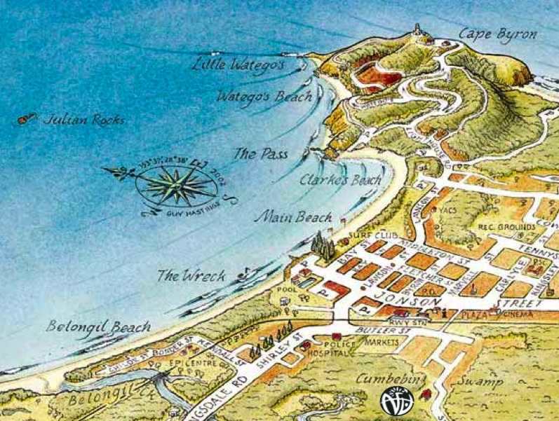
Map of Byron Bay NSW
Choose a Map of Byron Bay nsw to suit you
This page should give you a clearer idea of where each beach is in relation to each other and the neighboring area.
You can also get a good idea of the layout of Byron Bay town centre itself from the top map.
You can see a
Map of Beaches Byron-Ballina
here, to give you an idea of some of the great beaches lying between Byron Bay and Ballina.

The above map of Byron Bay is courtesy of
Rustys Byron Bay Guide
- a very comprehensive guide to Byron Bay which you can download and print to bring with you
Another good Byron Bay Map
- is supplied by
byron-bay.com
and comes in a downloadable PDF format which is easy to print and bring with you - very handy indeed.
To download to your computer, right click
here
and choose 'Save Target As...' if you're using a PC - if you're using a mac just click on the link.
Traveling north from Byron Bay, Belongil Beach stretches to the mouth of Belongil Creek and beyond, turning into Sunrise Beach then Tyagarah Beach - in all this is a 14 km stretch of unspoiled beach which goes all the way to Brunswick Heads.
On the southern side of Cape Byron Headland - the most northerly end of Tallows Beach is Cosy Corner - to get there, follow the road signs towards the Lighthouse.
Take the right-hand turnoff with a sign marked Tallows Beach - you can see the turnoff on the map above.
There is a parking area from which it is a short walk to Cosy Corner - the only place to be when there is a northerly or north-easterly blowing.
South of Byron Bay
Continuing south to the end of Tallows Beach you come to Broken Head, which leads to Seven Mile Beach, then Lennox Head.
From Lennox, you continue on down to Ballina
You can view the
Map of beaches Byron-Ballina
here
to get a better idea. You can also have a look at where
Ballina, Lennox Head and Bangalow lie in
relation to Byron Bay.

When you've finished with this map of byron bay nsw guide
click below to return to the surf or return home
Leave this Map of Byron Bay NSW and go to Byron Bay Surfing
Home | Byron Bay Beaches | Australian Beaches | World Beaches | Links | Ocean Scenes


